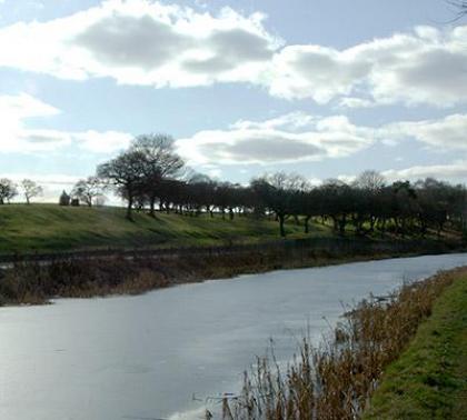
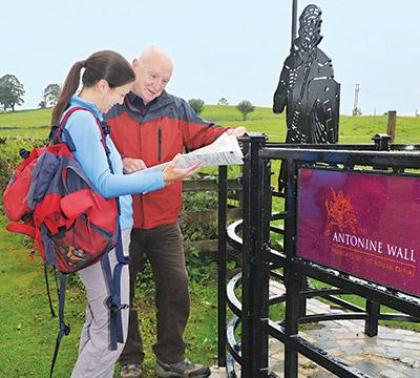
The Antonine Wall Interactive Map
Instructions
Horizontally scroll the image below to view the Antonine Wall. There are 24 forts and fortlets along the line of the wall. Each has a 'hotspot'indicated by a blue dotted line around the fort/let. Click on any of these hotspots to see either an image of the area around the fort today or an image of an artefact found there.
- Bishopton
The fort at Bishopton sits above the west shore of the River Clyde. It is in an ideal position to defend the approaches to the western end of the Antonine Wall some 2-3 km up-river on the opposite shore at Old Kilpatrick. The fort dates from the Antonine period, a replacement for the nearby Flavian fort at Barochan Hill. The fort covered an area of 2ha. Nothing survives of the fort, but there are excellent views over the Clyde to Dumbarton Rock and the hills beyond.
- Old Kilpatrick
This fort (1.7 ha.) marked the western terminus of the Antonine Wall, where it ended beside the River Clyde. Excavations in 1923-24 and 1929 revealed a stone headquarters building and granary, and other timber-framed buildings including barracks.There was a bath-house in an annexe south of the fort. The fort was built before the Antonine Wall, and then incorporated into it. The site is now covered by housing. Roman distance slab of the 20th Legion from Old Kilpatrick now in the Hunterian Museum.
- Duntocher
The fort (0.2 ha.) occupied a small hilltop site, now a public park. It was excavated in 1947-51 and 1977-78, to reveal a fort which had been built next to an existing fortlet. The fort defences consisted of a turf rampart with a stone base, and triple ditches on both the east and south sides. Within the fort a stone building and evidence of timber barracks were discovered. There was an annexe to the West of the fort. The site, which is in the care of West Dunbartonshire Council, is depicted on the ground by differential grass cutting.
- Cleddans
This fortlet, occupying a site midway between the forts at Duntocher and Castlehill, was found during trial excavation in 1979, measuring 18m by 17.6m. The turf rampart had a stone base 3.6m in width. The fortlet is earlier than the Antonine Wall.
- Castlehill
The fort (c. 1.4 ha.) occupied a fine hilltop site, whose crowning circle of beech trees is a distinctive landmark. It has never been excavated, but some of the ditches surrounding the fort have been detected as cropmarks and photographed from the air.
- Bearsden
The fort (0.9 ha.), whose site is now covered by housing, was excavated in 1973-81, prior to redevelopment of its northern half for apartment blocks. Excavation revealed barrack blocks, granaries and a possible workshop Also a latrine beside the bath-house. In an annexe to the east lay a bath-house, partly stone-built, partly timber-framed, now consolidated for public viewing. Two sections of the stone base of the Antonine Wall are visible in New Kilpatrick Cemetery on the east side of Bearsden, and the ditch in Roman Park to the west side. The bath-house is in the care of Historic Scotland and the Wall base sections and ditch are in the care of East Dunbartonshire Council.
- Summerston
Distance slab of the 2nd Legion from Summerston now in the Hunterian Museum
- Balmuildy
The fort (1.6 ha.) occupied sloping ground overlooking the River Kelvin, with the Campsie Hills beyond. It was comprehensively excavated in 1912-14 to reveal a stone headquarters building, commander's house and granaries, and a full range of timber-built barracks, together with a bath-house. East of the fort was a small annexe, containing another bath-house and timber buildings. Statue of Mars, the God of war, excavated from the site and now in the Hunterian Museum.
- Wilderness Plantation
This fortlet, revealed from the air in 1951, was excavated in 1965-66, lying halfway between the forts of Balmuildy and Cadder. It has commanding views across the Kelvin Valley. The fortlet is estimated to have measured 19.8 m by 17.5 m within the rampart. It was built at the same time as the Antonine Wall.
- Cadder
The Fort at Cadder: The fort (1.12 ha.) was excavated in 1929-31 to reveal a headquarters building, a commander's house, a bath-house and granaries which were stone-built, together with timber barracks. An external bath-house was located 80m east of the fort. Subsequently, the archaeological remains were completely removed by sand and gravel quarrying. Nothing of the fort remains visible.
- Glasgow Bridge
A fortlet, lying midway between the forts at Cadder and Kirkintilloch, was revealed here from the air in 1951. It has never been excavated.
- Kirkintilloch
The fort (c. 1.4 ha.), which lies in a public park, was partially excavated in 1953-61, but its outlines are imprecisely known. It had a fine position looking north across the Kelvin Valley to the Campsie Hills. A medieval castle, known as the Peel, was later constructed within the Roman fort. The Peel Park site is in the care of East Dunbartonshire Council. Distance slab of the 6th Legion from Kirkintilloch, now in the Hunterian Museum.
- Auchendavy
The fort (1.1 ha.) has never been excavated, but aerial photography has revealed the defensive ditches, which are visible on the ground at its south east corner, and the defences have also been revealed through geophysical survey. John Horsely (1732) stated that the fort was defended by a triple rampart and ditch. Altar to Diana and Apollo from Auchendavy now in the Hunterian Museum. One of several altars discovered when the Forth and Clyde Canal was being excavated in 1771.
- Bar Hill
The fort (1.3 ha.) occupied the summit of a very prominent hill, with wide views across the Kelvin Valley to the Campsie and Kilsyth Hills. It was excavated in 1902-5 and 1979-82, to reveal a stone headquarters building with a deep well in its courtyard, a granary and timber-built barracks and stores. There was a bath-house close to the fort's north west corner. A small pre-Roman fort sits on the hill to the east of the fort. A fine stretch of ditch runs on to the east. The site is in the care of Historic Scotland. Reconstruction of the fort at Bar Hill by Michael J. Moore.
- Croy Hill
The fort (0.6 ha.) sat atop a long east west ridge of hard dolerite, now partly quarried away. The fort was excavated in 1920, 1931, 1935 and 1975-78, to reveal a stone headquarters building and other structures. Predating the fort was a rectangular enclosure on the same site. In 1977 a fortlet was revealed on a summit 150m to the west. The section of ditch to the west and east of the fort is well preserved, while two "expansions", interpreted as beacon-platforms, sit on the west brow of the hill. The site is in the care of Historic Scotland.
- Westerwood
The fort (0.8 ha.) lay on the southern flank of the Kelvin Valley with good views to the north. Its outlines were established by excavation in 1932. The surrounding area is now a golf course. In 1963 an altar to the Silvanae (goddesses of the woodland) was discovered just west of the fort. In 1974-75 excavations revealed evidence of a field system to the west of the Military Way.
- Castlecary
The fort (1.4ha.) occupied a significant position on the east side of the Red Burn, with a good forward view. It was excavated in 1902 to reveal stone internal buildings including a headquarters and a bath-house. Fort defenses consisted of a wall of stone over 6' wide. There was a fortified annexe east of the fort. The site is in the care of Historic Scotland. Altar to Fortuna from Castlecary, now in the Hunterian Museum.
- Seabegs
This fortlet was discovered by trial excavation in 1977 at the west end of Seabegs Wood, between Castlecary and Bonnybridge. The fortlet measured 21.8m by 18m and was encircled by a rampart 3m wide and two ditches. The north rampart of the fortlet is the Antonine Wall itself. Also in Seabegs Wood is a well-preserved stretch of the Antonine Wall and the Military Way. There are no surface indications of the fortlet, but the ditch and rampart of the Antonine Wall and the course of the Military Way can be viewed. The site is in the care of Historic Scotland.
- Rough Castle
The fort (0.4 ha.), occupying a plateau east of the Rowan Tree Burn, is one of the smallest known on the line of the Antonine Wall, but because of the outstanding state of preservation of its defensive ramparts and ditches, together with the exceptional survival of the Antonine Wall frontier works to both west and east, it is much visited today. In an annexe to the east. North of the fort was a series of defensive pits (or lilia) of which some part can be seen. The site is in the care of Historic Scotland.
- Watling Lodge
The fortlet was excavated in 1894 and 1972-74. It guarded the Roman road which ran northwards from the Antonine Wall to the fort at Camelon and beyond. The fortlet measures c. 18.5m by 15.5m. There are no surface traces of the fortlet, but the Antonine ditch is well-preserved. The site is in the care of Historic Scotland.
- Falkirk
The fort, long suspected, was discovered in 1991 in the area known as the Pleasance, on the site of a scout hut. The first occupation pre-dated the Antonine Wall, but it was rebuilt with new timber buildings with the construction of the Antonine Wall. The overall layout and size of this fort remain uncertain. No surface traces of this fort can be seen. The Antonine Wall ditch survives well in Callendar Park, which is in the care of Falkirk Council.
- Mumrills
Excavations in 1923-28 and 1958-60 established Mumrills as the largest known fort on the Antonine Wall, covering an area of 2.6ha. Also discovered through excavation were a stone headquarters building, commander's house and granaries, together with a bath-house and timber-built barracks. The large size suggests that this fort was intended to accommodate a cavalry unit.
- Inveravon
The fort was discovered, on low ground east of the River Avon, in 1991 in advance of pipelaying, though earlier work in 1967 had revealed stone walling hereabouts. Its size remains uncertain. Discoveries of a Samian dish dating from c. AD 155-160 and mortaria assemblage suggest that this fort continued in occupation until this time. There are no surface remains of this fort.
- Kinneil
This fortlet was discovered in 1978, and fully excavated in 1981. It measures 18m by 21m, and was defended by a rampart with a stone base. The internal buildings of barracks and stores were timber built. The fortlet has been fully excavated and is on public display. Concrete slabs mark the line of the rampart and timber posts indicate where the gateways and two interior buildings were located. This site is in the care of Falkirk Council.
- Carriden
Although the wall ended at Bridgeness Tower in Bo'ness, 1km West of Carriden, this fort can be taken as the eastern terminus of the Roman frontier line. It was located from the air in 1945 and covered an area of 1.6ha. No interior excavation has taken place. A geophysical survey was carried out on the site in 2007. An extract of the report can be found in the Research section of this web site. The Bridgeness distance slab (shown below) found in 1868 at the east end of the Antonine Wall. Now in the National Museum of Scotland, Edinburgh.


